




Mount Dukono Volcano Hike: Complete Guide For Halmahera
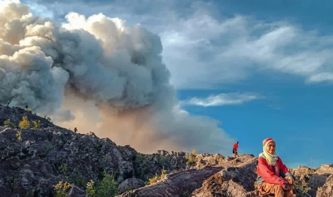
Mount Dukono is one of the most persistently active volcanoes in Indonesia. Rising from the forested landscape of northern Halmahera in North Maluku, Dukono has produced near-continuous explosive activity for decades, regularly sending ash above its crater complex.
For years, the Mount Dukono Volcano Hike was known among adventurous travelers for a demanding approach through tropical jungle and rough volcanic terrain. Older photos and travel reports often show hikers standing surprisingly close to the erupting crater.
That older experience is no longer an appropriate description of a current trip. In May 2026, the North Halmahera government ordered Mount Dukono hiking access permanently closed after a deadly eruption involving hikers near the volcano. Dukono also remains actively erupting, with an official exclusion zone around Malupang Warirang Crater.
This guide therefore covers much more than an old trail description. It explains Dukono’s current status, the May 2026 incident, where the volcano is located, how to reach northern Halmahera, the historical hiking terrain, where to stay, transportation, the volcano’s geology, ash hazards, what visitors can still see legally, nearby attractions and how to plan a North Halmahera trip responsibly.


Mount Dukono Guide Contents
- Current Dukono Status
- Is Mount Dukono Closed?
- May 2026 Eruption
- Where Is Mount Dukono?
- Mount Dukono Facts
- Mount Dukono Map
- How To Get To North Halmahera
- From Ternate
- Airports Near Dukono
- Tobelo
- Mamuya
- Getting Around
- Historical Dukono Hike
- Trail Terrain
- Difficulty
- Guides
- Dukono Geology
- Current Volcanic Activity
- Volcanic Hazards
- Volcanic Ash
- Weather
- What To Bring
- Photography
- Where To Stay
- How Many Days?
- Things To Do Nearby
- FAQ
Current Mount Dukono Status
Dukono remains an actively erupting volcano.
The Smithsonian Global Volcanism Program, using information from Indonesia’s Pusat Vulkanologi dan Mitigasi Bencana Geologi (PVMBG), reported continued eruptive activity during September 2026.
During 10–15 September, white and gray ash plumes were observed rising approximately 200 to 1,100 meters above the summit.
The volcano remained at Level II on Indonesia’s four-level alert system.
The official recommendation remained to stay at least 4 kilometers away from Malupang Warirang Crater.
On 23 September 2026, monitoring detected 98 explosions at Dukono.
This is important because Dukono can appear relatively calm between explosions. A period without a large visible ash plume does not mean that the crater has suddenly become safe.
Is Mount Dukono Open For Hiking?
No. The current official position is that hiking Mount Dukono is closed.
On 8 May 2026, the government of North Halmahera issued letter number 500.10.5.3/491 ordering a permanent closure of entry points used for Mount Dukono hiking.
The order instructed hiking managers and relevant parties not to grant climbing permission and called for access points to be monitored and closed.
The government stated that violations could lead to warnings, blacklisting and legal consequences under applicable regulations.
No later official reopening announcement was found when this guide was updated in September 2026.
What Happened At Mount Dukono In May 2026?
The May 2026 eruption is one of the most important events to understand before reading older Dukono hiking guides.
According to the North Halmahera government, a group of 20 hikers was on Dukono during the 8 May eruption.
Seventeen were initially reported safe or evacuated, while three hikers — one Indonesian national and two Singaporean nationals — died.
A joint operation involving Basarnas, BPBD, the Indonesian military, police and residents of Mamuya searched the upper mountain and recovered the victims over the following days.
The incident led directly to stricter government action and the permanent hiking closure.
It also demonstrates why old online photos of people standing on the crater edge should not be treated as evidence that the same activity is currently legal or acceptably safe.

Where Is Mount Dukono?
Mount Dukono is located in North Halmahera Regency, North Maluku Province, Indonesia.
Halmahera is the largest island in the Maluku archipelago and is shaped roughly like a smaller version of Sulawesi.
The island is mountainous, forested and much less developed for international tourism than Bali, Java or Lombok.
Dukono lies in northern Halmahera near the communities of the Galela region.
Tobelo is the most useful urban base for travelers. Mamuya is much closer to the volcanic area and is associated with the Dukono observation and former hiking access area.
Mount Dukono At A Glance
| Detail | Information |
|---|---|
| Country | Indonesia |
| Province | North Maluku |
| Island | Halmahera |
| Volcano | Dukono volcanic complex |
| Smithsonian elevation | 1,273 m / 4,177 ft |
| Coordinates | Approximately 1.6992° N, 127.8783° E |
| Volcanic arc | Halmahera Volcanic Arc |
| Activity | Almost continuous explosive activity since 1933 |
| Current alert | Level II when checked in September 2026 |
| Exclusion radius | 4 km from Malupang Warirang Crater |
| Hiking access | Officially closed |
| Useful travel base | Tobelo |
Map Of Mount Dukono & North Halmahera
This map shows the general position of Mount Dukono in northern Halmahera. It is useful for understanding the relationship between the volcano, Tobelo and the Galela/Mamuya area.
The map is for regional orientation only. Do not use Google Maps, offline hiking apps or old GPS tracks to enter the closed volcano area.
How To Get To North Halmahera
Getting to Dukono’s region takes more planning than reaching Indonesia’s well-known volcanoes around Bali or Java.
The main international-style gateway for North Maluku is generally Sultan Babullah Airport in Ternate.
From Ternate, travelers can continue toward Halmahera by air or by a combination of boat and road transport, depending on current schedules.
Indonesia’s official tourism site notes that Halmahera’s transport system also uses local bemo, mikrolet, bentor and ojek services.
Ternate To North Halmahera
Ternate is one of the easiest places to begin a North Maluku trip because it has substantially more flight connections than northern Halmahera.
From Ternate, there are two broad strategies.
Fly To Northern Halmahera
Indonesia Travel describes flights from Ternate to the Galela area near Tobelo.
Gamar Malamo Airport serves Galela in North Halmahera.
Flight frequency on regional routes can vary, so confirm the actual operating day before building your itinerary.
Boat & Road Through Halmahera
Another option is to cross from Ternate toward Halmahera and continue north overland.
This route takes much longer but can work well if you are exploring several parts of Halmahera rather than traveling only to Tobelo.
Airports Near Mount Dukono
Gamar Malamo Airport
Gamar Malamo Airport is located in the Galela area of North Halmahera and is geographically convenient for northern Halmahera.
The Indonesian Ministry of Transportation lists it as a domestic airport.
Kuabang Airport
Kuabang Airport is located at Kao in North Halmahera.
The Indonesian Ministry of Transportation opened an expanded passenger terminal here in 2021 with the aim of improving connectivity for North Halmahera.
Actual flight schedules can change, so neither airport should be assumed to have convenient daily flights without checking current airline schedules.
Tobelo: Best Base For North Halmahera
Tobelo is the most practical place to base yourself when exploring northern Halmahera.
Compared with smaller villages, it offers a better selection of accommodation, food, shops, fuel, ATMs and transport.
Tobelo is also useful if you want to continue north toward Galela or combine Halmahera with Morotai.
Even though Dukono hiking is closed, Tobelo still makes sense as a base for exploring the wider region.
Mamuya Village & Dukono
Mamuya is closely associated with Dukono because of its position near the volcano and its volcano monitoring facilities.
During the May 2026 emergency, Mamuya served as an important operational area for search and rescue activity.
The village should not be treated simply as a trailhead for ignoring the mountain closure.
Visitors traveling through this part of Halmahera should respect local authorities, residents and all closure signage.
Getting Around North Halmahera
Independent transport can make a major difference in North Halmahera because attractions are spread across a relatively large area.
Common local options include:
- bemo and minibuses on local routes;
- bentor;
- ojek motorcycle taxis;
- motorbike rental where available;
- private cars with drivers.
For travelers carrying luggage or visiting multiple remote locations, a private car or locally arranged driver is generally the easiest option.
What Was The Traditional Mount Dukono Hike Like?
Before the 2026 closure, Dukono was known as a challenging jungle-and-volcano trek.
The traditional approach began on the Mamuya side and climbed from low tropical terrain toward the volcanic complex.
Travelers first passed through humid forest before eventually reaching increasingly barren volcanic ground.
The upper landscape was dramatically different from the jungle below: black and gray deposits, ash, broken lava and views toward Dukono’s crater system.
Older accounts frequently describe long day hikes or overnight trips.
This historical description is included to explain why Dukono became famous among volcano hikers. It is not a route instruction for current use.

Mount Dukono Terrain
Tropical Forest
The lower slopes are humid, green and heavily vegetated.
Rain can turn dirt tracks into deep mud, and tropical heat means hikers historically dealt with high humidity even before reaching higher elevations.
Volcanic Ground
Higher terrain becomes rougher and increasingly dominated by volcanic deposits.
Loose stones, old lava, ash and irregular ground make movement slower than ordinary trail distance suggests.
Exposure
Once outside the forest, there is substantially less protection from sun, wind, rain and airborne ash.
How Difficult Was The Dukono Hike?
The historical full hike was generally considered strenuous.
The challenge came from a combination of:
- long duration;
- tropical heat and humidity;
- mud;
- rough forest terrain;
- substantial elevation gain;
- uneven lava and ash;
- limited facilities;
- volcanic exposure.
Some older trip reports describe full days lasting around 10–12 hours.
Those figures should not be used to plan a current climb because the route is now officially closed.
Do You Need A Mount Dukono Guide?
Historically, travelers were strongly advised to use a local guide because the forest approach could be confusing and conditions changed frequently.
Under the current closure, however, the important point is different:
A guide cannot legally override an official mountain closure or a PVMBG exclusion zone.
Do not accept offers from anyone promising access to the crater simply because they know a hidden path.
Why Is Mount Dukono So Active?
Dukono is part of the Halmahera Volcanic Arc, an active volcanic zone related to subduction and complex tectonic processes around eastern Indonesia.
Unlike a simple isolated cone, Dukono is a broad volcanic complex with multiple overlapping craters and peaks.
The Smithsonian describes the complex as having a broad, low-profile edifice.
Malupang Warirang is part of this system and contains a crater roughly 700 by 570 meters.
Dukono has produced almost continuous explosive activity since 1933.
Its eruption history goes back much further. A major eruption around 1550 produced a lava flow significant enough to fill a former strait between Halmahera and the Gunung Mamuya cone.
What Does A Dukono Eruption Look Like?
Dukono commonly produces explosive ash emissions.
Some events create relatively modest columns that rise a few hundred meters above the summit. Stronger explosions can send ash much higher.
The plume’s direction changes with the wind, meaning ashfall can affect different communities at different times.
This is why authorities emphasize not only crater distance but also respiratory protection when ash moves across inhabited areas.
Mount Dukono Hazards
The danger at Dukono is not limited to flowing lava.
Explosive Eruptions
Explosions may occur repeatedly, sometimes with little practical warning to someone standing close to the crater.
Volcanic Projectiles
Explosive eruptions can throw blocks and other material around the crater area. This is one reason crater-distance recommendations must be taken seriously.
Ash
Fine ash can irritate eyes and the respiratory system and can severely reduce visibility.
Volcanic Gases
Gas concentrations can be dangerous close to active volcanic vents.
Heavy Rain & Drainages
Volcanic sediment can be remobilized during heavy rainfall, creating hazards in drainage channels and low areas.
Dukono Volcanic Ash
Ash is one of the most common ways Dukono affects people living far beyond the crater.
Wind direction determines which villages or roads may receive ash on a particular day.
When visiting northern Halmahera during active ash emissions, carrying a well-fitting particulate mask is sensible even if you have no intention of approaching the volcano.
People with asthma or other respiratory conditions should take additional care.

Weather Around Mount Dukono
North Halmahera has a humid tropical climate.
Weather around the volcano can change quickly, and clouds may hide the summit even when conditions lower down are clear.
Heavy rain can also turn forest roads and trails muddy.
For current travel planning, a short-term weather forecast is more useful than relying entirely on a generic “best season” recommendation.
Remember that good weather does not make a closed volcano open.
What To Bring To North Halmahera
Even if you are only visiting the region around Dukono rather than climbing it, a few items are particularly useful:
- N95, KN95 or similar particulate mask for ash;
- rain jacket;
- closed walking shoes;
- drinking water;
- sunscreen;
- insect repellent;
- power bank;
- offline maps;
- cash;
- waterproof bag for electronics;
- basic medication and first-aid supplies.
Remote sections of Halmahera have fewer shops and services than major Indonesian tourism centers, so carrying essentials is worthwhile.
Mount Dukono Photography
You do not need to stand at the crater to photograph an active volcano.
Large Dukono ash columns can sometimes be visible from communities and roads well outside the exclusion area.
A telephoto lens can be much more useful than trying to physically approach the volcano.
Weather, cloud cover and wind direction determine whether the mountain is visible.
Never move closer simply because cloud cover makes the eruption difficult to photograph.
Where To Stay
Tobelo
Tobelo is the best all-round base for most independent travelers.
It has the strongest combination of accommodation, restaurants, ATMs, transport and supplies in the area.
Galela Area
Staying farther north can be useful if your itinerary includes Galela, Talaga Biru or Gamar Malamo Airport.
Accommodation choices are more limited than Tobelo, so arrange rooms before arriving if you are traveling during a busy period.
How Many Days For North Halmahera?
Even with Dukono closed, northern Halmahera deserves more than a rushed overnight visit.
Two days can cover Tobelo and a few nearby attractions.
Three days allows a more relaxed visit to the Galela/Mamuya area and the coast.
Four or more days makes sense if you plan to continue to remote beaches, explore more of Halmahera or connect with Morotai.
Things To Do Near Mount Dukono
Talaga Biru
Indonesia’s official tourism site highlights Talaga Biru, meaning Blue Lake, as a natural pool with clear water near Mamuya in the Galela district.
It is a useful alternative stop if your original reason for coming to the area was Dukono.
Halmahera Coast
Northern Halmahera has beaches and coastal scenery that receive far fewer international visitors than major Indonesian islands.
Tobelo
Spend time around Tobelo itself for local food, coastal views and everyday North Maluku life.
Morotai
Travelers with extra time can continue north to Morotai, which is connected with Tobelo by sea transport and is known for beaches, diving and Second World War history.
Responsible Volcano Tourism
Dukono is a good example of why adventure travel needs to change when conditions change.
A photo or trip report from 2018, 2022 or even early 2026 may accurately describe what someone did at that time, but it does not create a permanent right to repeat the same activity.
Volcano regulations respond to current hazards.
Respect:
- government closure notices;
- PVMBG exclusion zones;
- local village restrictions;
- volcano-observatory instructions;
- emergency-service warnings.
Do not pressure local guides or residents to take you into a restricted area.
Frequently Asked Questions
Is Mount Dukono still erupting?
Yes. Dukono continued producing explosive activity in September 2026.
Is Mount Dukono open for hiking?
No. North Halmahera authorities issued a permanent hiking closure in May 2026, and no official reopening was found when this guide was updated.
Can I hike to the Dukono crater with a guide?
No guide can override the official closure or PVMBG’s exclusion zone. The current recommendation is to stay at least 4 km from Malupang Warirang Crater.
Why was Mount Dukono closed?
The closure followed a deadly eruption involving hikers on 8 May 2026. North Halmahera authorities stated that the closure was intended to protect residents and visitors from ongoing volcanic hazards.
Where should I stay for Dukono?
Tobelo remains the most practical travel base for northern Halmahera.
Which airport is closest?
Gamar Malamo Airport in Galela is geographically close to northern Halmahera, while Kuabang Airport at Kao is another regional airport. Many travelers also enter North Maluku through Ternate.
How high is Mount Dukono?
The Smithsonian Global Volcanism Program lists Dukono at 1,273 meters above sea level.
Why does Mount Dukono erupt so often?
Dukono is an active volcanic complex in the Halmahera Volcanic Arc and has experienced almost continuous explosive eruptions since 1933.
Can you see Dukono without hiking?
Depending on cloud cover, ash direction and your location, the mountain or its ash plume may be visible from legal locations well beyond the crater exclusion zone.
Is Mount Dukono worth visiting now?
It can still be worthwhile to visit North Halmahera if you understand that the volcano itself is closed to hiking. Tobelo, Galela, Talaga Biru, coastal areas and the broader Halmahera landscape can make the journey worthwhile without entering the restricted mountain.
Final Thoughts
Mount Dukono deserves its reputation as one of Indonesia’s most extraordinary volcanoes.
Its almost continuous explosive activity, remote Halmahera setting and dramatic volcanic landscape made it famous among adventurous hikers long before the region received much international tourism.
But Dukono also illustrates an important reality of volcano travel: yesterday’s hiking route may become today’s exclusion zone.
The events of May 2026 were a serious reminder of how quickly conditions around an active crater can become deadly.
For now, the responsible way to experience the region is to respect the closure, stay outside the official hazard radius and explore northern Halmahera without attempting to recreate old crater-rim trips.
If authorities formally reopen Dukono in the future, check the new rules from scratch rather than assuming the old route and access system will return unchanged.
Sources
North Halmahera Government — Permanent Mount Dukono Hiking Closure
Official information about the May 2026 closure order.
North Halmahera Government — May 2026 Search & Evacuation
Official local-government account of the eruption incident and recovery operation.
Smithsonian Global Volcanism Program — Dukono
Volcano geology, coordinates, eruption history and current reports.
Smithsonian / USGS — Dukono Activity, September 2026
Current ash emissions, Level II alert and 4 km exclusion recommendation.
MAGMA Indonesia — PVMBG
Check the latest official volcano alert status before traveling in the Dukono region.
Indonesia Travel — Halmahera
Official tourism information for Halmahera, regional transport and nearby attractions.
Indonesia Ministry of Transportation — Kuabang Airport
Official information about Kuabang Airport in North Halmahera.
Wikimedia Commons — Dukono Images
Original image pages and licensing information for Dukono media used above.
Last checked: September 2026. Volcano activity, exclusion zones, aviation schedules and local access can change. For safety and legal access, current PVMBG and North Halmahera government instructions take priority over this or any other travel guide.